|
|||||||


|


|
|
 |
|
|
Strumenti |
 24-03-2006, 11:03
|
#41 |
|
Senior Member
Iscritto dal: Nov 2000
Città: Sospeso nell'incredibile
Messaggi: 830
|
sono arrivate le prime quattro immagini della HiRise su questo blog ci sono tutti gli aggiornamenti http://hiroc.lpl.arizona.edu/first_images/
|

|

|
|
24-03-2006, 18:00
|
#42 |
|
Senior Member
Iscritto dal: Nov 2000
Città: Sospeso nell'incredibile
Messaggi: 830
|
First Images from the HiRISE Mars Camera!
 Detail of First Mars Image from Newly Arrived Camera This view shows a full-resolution portion of the first image of Mars taken by the High Resolution Imaging Science Experiment camera (HiRISE) on NASA's Mars Reconnaissance Orbiter. The spacecraft, launched Aug. 12, 2005, began orbiting Mars on March 10, 2006. The image is of an area in Mars' mid-latitude southern highlands. HiRISE took this first test image from orbit on March 24, 2006, from an altitude of 2,489 kilometers (1,547 miles), achieving a resolution of 2.49 meters (98 inches) per pixel, or picture element. The smallest objects of discernable shape are about three pixels across. An image acquired at this latitude during the Mars Reconnaissance Orbiter's main science phase, beginning in fall 2006, would be taken from an altitude of about 280 kilometers (174 miles) and have a resolution of 28 centimeters (11 inches) per pixel. This view covers an area about 2.7 kilometers (1.6 miles) wide, a subset (less than one-half of 1%) of the broader image. The quality of this test image is spectacular, with no hint to the eye of any smear or blurring. A high signal-to-noise ratio reveals fine details even in the shadows. Image Credit: NASA/JPL-Caltech/University of Arizona  First Mars Image from Newly Arrived Camera This view shows the ground covered in the first image of Mars taken by the High Resolution Imaging Science Experiment camera (HiRISE) on NASA's Mars Reconnaissance Orbiter. The spacecraft, launched Aug. 12, 2005, began orbiting Mars on March 10, 2006. HiRISE took this first test image from orbit on March 24, 2006, from an altitude of 2,489 kilometers (1,547 miles). Images taken during the mission's main science phase, beginning in fall 2006, will be from an altitude about one-tenth as far from the ground, gaining even higher resolution. This image is a mosaic combining 10 side-by-side exposures taken through red filters, presented at greatly reduced scale. The full product would be 20,000 pixels wide by 9,500 pixels high. The white box at lower right indicates the position of a sample image [link to AEB1-cut-full1] offered in full resolution. The quality of this test image is spectacular, with no hint to the eye of any smear or blurring. A high signal-to-noise ratio reveals fine details even in the shadows. The scene covers an area 49.8 kilometers (30.9 miles) wide and 23.6 kilometers (11.7 miles) high, of landscape typical of Mars' mid-latitude southern highlands. The location is 34 degrees south latitude, 305 degrees east longitude. An old, muted crater lies at the middle of the scene, with sets of channels to the left and right. Superimposed on parts of this terrain is a much younger, layered mantle of debris. The debris mantle is smooth in places but rough in other areas where it may have partially sublimated. This suggests that the debris mantle is (or was) rich in volatiles such as ices of water, carbon dioxide or both. Also superimposed on the landscape are many small sharp-rimmed impact craters and wind-blown dunes. This image illustrates processes that may have involved water both on ancient Mars (channels and eroded craters) and much more recently in Mars' history (volatile-rich debris mantle). The radiometric and geometric processing of this image is very preliminary. In particular there are mismatches visible at full resolution along the seams between the 10 side-by-side images from separate CCDs (charge-coupled devices, which are electronic optical sensors). Image Credit: NASA/JPL-Caltech/University of Arizona |
|
|
|
|
24-03-2006, 20:54
|
#43 |
|
Senior Member
Iscritto dal: Jan 2002
Città: Napoli
Messaggi: 1727
|
a colori nn c'è niente?
__________________
Se buttassimo in un cestino tutto ciò che in Italia non funziona cosa rimarrebbe? Il cestino. |
|
|
|
|
24-03-2006, 22:44
|
#44 | |
|
Senior Member
Iscritto dal: Oct 2000
Città: UK
Messaggi: 7458
|
Quote:
__________________
"Questo forum non è un fottuto cellulare quindi scrivi in italiano, grazie." (by Hire) Le mie foto su Panoramio - Google Earth |
|
|
|
|
|
25-03-2006, 01:42
|
#45 | |
|
Senior Member
Iscritto dal: Mar 2002
Città: Treviso
Messaggi: 911
|
Semplicemente impressionante!
Comunque HiRISE non produrra' immagini in colori reali (RGB) bensi' in: Quote:
|
|
|
|
|
|
25-03-2006, 09:17
|
#46 | |
|
Senior Member
Iscritto dal: Oct 2000
Città: UK
Messaggi: 7458
|
Quote:
__________________
"Questo forum non è un fottuto cellulare quindi scrivi in italiano, grazie." (by Hire) Le mie foto su Panoramio - Google Earth |
|
|
|
|
|
25-03-2006, 09:36
|
#47 | |
|
Member
Iscritto dal: Nov 2005
Messaggi: 154
|
le camere hanno una risoluzione di 800 Mpixel
è pazzesco inoltre gestire in real time tutte le operazioni che deve svolgere la sonda dev'essere difficilissimo : Quote:
__________________
"la scelta giusta non è sempre la più saggia,ma è quella che non porta con sè rimpianti" . pietro84 |
|
|
|
|
|
25-03-2006, 10:38
|
#48 | |
|
Senior Member
Iscritto dal: Mar 2002
Città: Treviso
Messaggi: 911
|
Quote:
quello di cui non sono sicuro e' se le acquisizioni possono essere fatte simultaneamente nelle 3 bande o quantomeno in G-B e R (anche per motivi di occupazione della memoria di massa interna) Inutile dire che spero di essere smentito e di vedere il prossimo autunno delle bellissime immagini full color! |
|
|
|
|
|
25-03-2006, 10:50
|
#49 | |
|
Member
Iscritto dal: Nov 2005
Messaggi: 154
|
Quote:
Mi chiedo come mai abbiano fornito il sistema di elaborazione di poca memoria(relativamente). 20 GB in tutto quando una sola immagine occupa circa 3GB. Per non riempire la memoria deve trasmettere in continuazione.
__________________
"la scelta giusta non è sempre la più saggia,ma è quella che non porta con sè rimpianti" . pietro84 |
|
|
|
|
|
25-03-2006, 11:40
|
#50 | |
|
Senior Member
Iscritto dal: Oct 2000
Città: UK
Messaggi: 7458
|
Quote:
__________________
"Questo forum non è un fottuto cellulare quindi scrivi in italiano, grazie." (by Hire) Le mie foto su Panoramio - Google Earth |
|
|
|
|
|
25-03-2006, 11:42
|
#51 | |
|
Senior Member
Iscritto dal: Oct 2000
Città: UK
Messaggi: 7458
|
Quote:
Forse ho ancora un link interessante... sì... è sui rover ma direi che va bene comunque: http://www.atsnn.com/story/30048.html
__________________
"Questo forum non è un fottuto cellulare quindi scrivi in italiano, grazie." (by Hire) Le mie foto su Panoramio - Google Earth |
|
|
|
|
|
26-03-2006, 13:59
|
#52 | |
|
Member
Iscritto dal: Nov 2005
Messaggi: 154
|
Quote:
quando ho tempo mi leggo l'articolo che hai postato. dei filtri regolabili lasciano passare in sequenza le tre bande ad ogni foto quindi....
__________________
"la scelta giusta non è sempre la più saggia,ma è quella che non porta con sè rimpianti" . pietro84 |
|
|
|
|
|
01-04-2006, 10:47
|
#53 |
|
Senior Member
Iscritto dal: Jun 2004
Città: BOLZANO/BOZEN
Messaggi: 14871
|
|
|
|
|
|
05-04-2006, 13:24
|
#54 | |
|
Senior Member
Iscritto dal: Mar 2002
Città: Treviso
Messaggi: 911
|
Aerobraking
da spaceflightnow.com
Mars Reconnaissance Craft begins adjusting orbit MISSION STATUS REPORT Posted: March 31, 2006 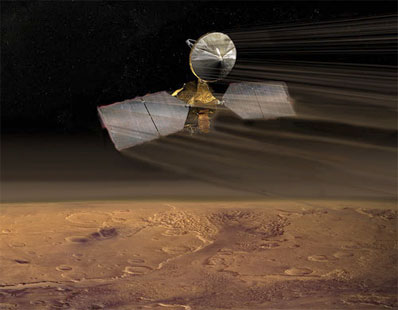 Quote:
http://www.spaceflightnow.com/news/n...roaerobraking/ e le fonti della NASA: http://mars.jpl.nasa.gov/mro/gallery...robraking.html 
|
|
|
|
|
|
08-04-2006, 11:49
|
#55 |
|
Senior Member
Iscritto dal: Oct 2000
Città: UK
Messaggi: 7458
|
Son arrivate le prime immagini di test ad alta risoluzione, vacca boia son 261Mb di tiff (o 39mb di jpg), con questa missione faccio pacchi di dvd di foto
__________________
"Questo forum non è un fottuto cellulare quindi scrivi in italiano, grazie." (by Hire) Le mie foto su Panoramio - Google Earth |
|
|
|
|
22-08-2006, 17:01
|
#56 |
|
Senior Member
Iscritto dal: Mar 2002
Città: Treviso
Messaggi: 911
|
Si sa piu' niente di come stia procedendo l'aerobraking? sul sito ufficiale l'ultima news risale a maggio..
http://mars.jpl.nasa.gov/mro/ |
|
|
|
|
22-08-2006, 17:05
|
#57 | |
|
Senior Member
Iscritto dal: Oct 2000
Città: UK
Messaggi: 7458
|
Quote:
__________________
"Questo forum non è un fottuto cellulare quindi scrivi in italiano, grazie." (by Hire) Le mie foto su Panoramio - Google Earth |
|
|
|
|
|
31-08-2006, 14:13
|
#58 | |
|
Senior Member
Iscritto dal: Mar 2002
Città: Treviso
Messaggi: 911
|
Finalmente!
Quote:
|
|
|
|
|
|
31-08-2006, 14:14
|
#59 |
|
Senior Member
Iscritto dal: Mar 2002
Città: Treviso
Messaggi: 911
|
Nuova anche la pagina sulla posizione della sonda:
http://mars.jpl.nasa.gov/mro/mission/rightnow.html questo e' un esempio  (non per svaccare, ma l'interfaccia fa molto Doom3 |
|
|
|
|
06-09-2006, 16:18
|
#60 | |
|
Senior Member
Iscritto dal: Mar 2002
Città: Treviso
Messaggi: 911
|
da Nasa.gov:
Quote:
|
|
|
|
|

|
|
| Strumenti | |


|
|

Tutti gli orari sono GMT +1. Ora sono le: 11:02.